
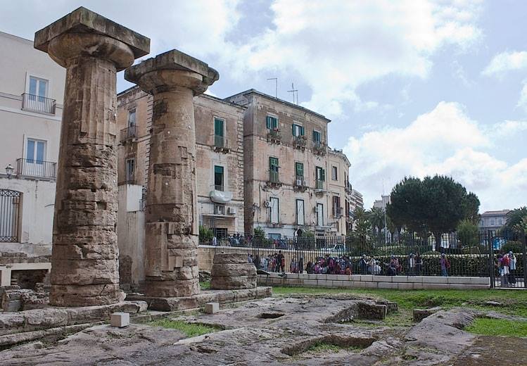
The project aims to deepen the archaeological knowledge of Taras, one of the most relevant cities of Magna Graecia, founded by Sparta, through an interdisciplinary approach including archaeology, topography, history of architecture, and computer engineering. Thanks to the full support of the National Superintendence of Taranto, a complete mapping and arrangement of all the architectural remains of the ancient settlement, from the Greek until the Medieval period, will be carried out.
The resulting data will be contextualised in the first archaeological map of Taras, based on a GIS platform. The latter will store all the collected descriptive, graphical, analytical, alphanumerical data, both edited and still not published (but made available by the Superintendence), organising them in spatial and chronological units that can be processed and enquired by the users. So, the project will produce a definitive advancement in the state of art, contributing to reconstruction of the urban landscape of the ancient polis in its different phases.
Moreover, the designed platform, based on state-of-the-art neural networks capable to provide both classification and recommendation capabilities, will run on two levels: for internal use (goal 1: for practitioners and Superintendence staff), and for external use (goal 2: for the large audience) through an innovative App, delivering both scientific data for expert users and educational information for the general public. Such an integrated platform has never been implemented in a mixed archaeological-architectural framework and will contribute to a better knowledge of any ancient city as well as its protection and valorisation (goal 1), besides increasing and facilitating tourism (goal 2).
The creation of the archaeological map based on the GIS will be jointly carried out by Unit 1 and 3, that have already coordinated financed projects in this field and have a proven expertise in investigating Greek urban settlements, while the development of the integrated platform addressing the specialised and not specialised public will be in charge of Unit 2. The architectural study of the buildings (Research Unit 3), reconstructed in scientifically proven 2D and 3D representations, will comprise an analysis of the architectural fragments, catalogued through a graphic reconstruction of their profiles.
The Tarantine ancient architecture will be a case study for the development of a second App, based on Artificial Intelligence, that automatically recognizes specific architectural features, framing them in the history of the architecture (Research Unit 2). The study of the ancient monuments will be accompanied by a throughout analysis of the social and religious life of the city, moving from the research on its sacred areas and its relationship with Sparta (Research Unit 1). The social and religious aspects of Taras will be also spread to the public, thanks to the cited App.
The developed platform, which will be applied in the Tarantine context as a proof of concept, can become a reference model for an effective multi-level organisation and management of archaeological and architectural data, possibly to be adopted by many other cultural institutions.